📐 Hamilton Zoo Coordinate Navigator 📊 Kaiwhakarea Tauwāhi Kōpere Kirikiriroa
🎯 Mathematical Mission Brief
Welcome to advanced zoo navigation! You'll use proper coordinate geometry to solve real problems at Hamilton Zoo.
📊 Key Mathematical Concepts:
- Coordinate System: (x, y) notation with origin at (0, 0)
- Scale Factor: 1 grid square = 80 metres in real life (matching the map schematic below)
- Distance Formula: Calculate exact distances between points
- Coordinate Plane: Quadrant I navigation (positive values only)
- Problem Solving: Apply mathematics to real-world scenarios
Scale: 1 grid square = 80m, so multiply your grid-unit distance by 80 for the real distance in metres.
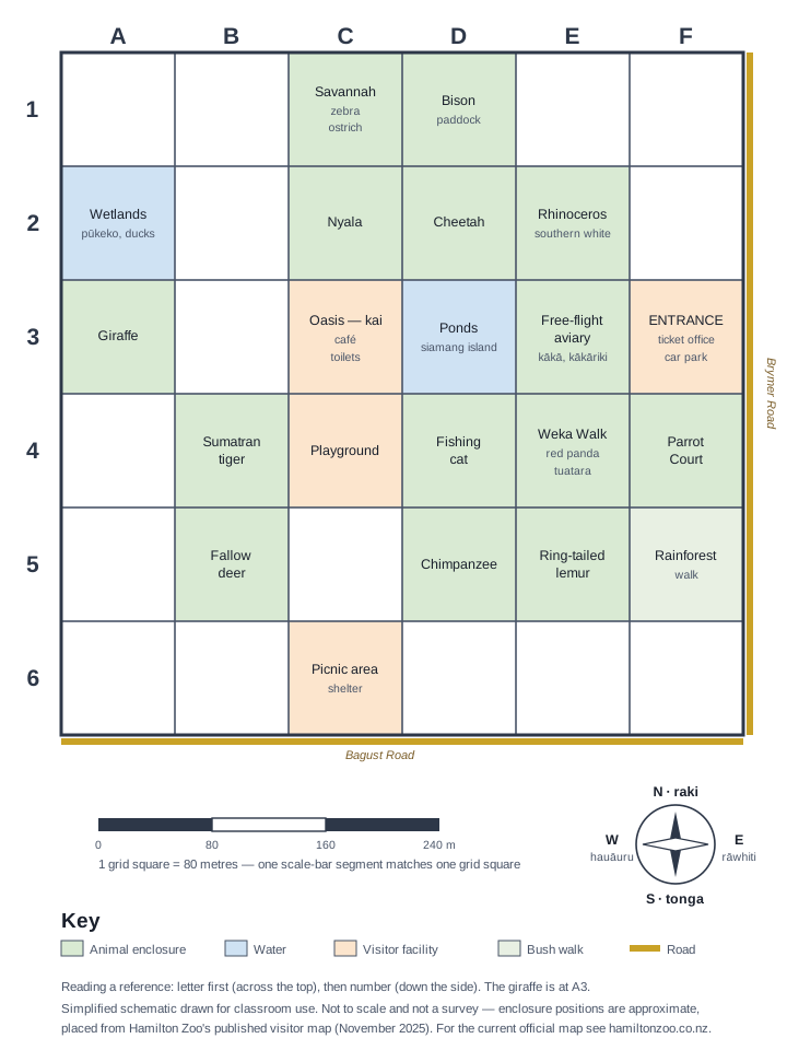
Activity 1: Precise Coordinate Mapping
Task: Identify the exact coordinates (x, y) for each location. Remember: x is horizontal (across), y is vertical (up).
| Location | x-coordinate | y-coordinate | Coordinate Pair (x, y) |
|---|---|---|---|
| 🚗 Car Park (Origin A) | 0 | 0 | (0, 0) |
| 🦒 Giraffe Exhibit | (, ) | ||
| 🐘 Elephant Enclosure | (, ) | ||
| 🐅 Tiger Territory | (, ) | ||
| 💧 Wetlands Area | (, ) |
Activity 2: Distance Calculations
🧮 Mathematical Method:
Step 1: Identify coordinates (x₁, y₁) and (x₂, y₂)
Step 2: Apply distance formula: d = √[(x₂ - x₁)² + (y₂ - y₁)²]
Step 3: Multiply your grid-unit answer by the scale factor (80 m per grid square) for the real distance
Calculate the exact distance from Car Park A (0, 0) to each animal exhibit:
🦒 Distance to Giraffes:
Giraffe coordinates: (, )
Calculation: d = √[( - 0)² + ( - 0)²]
d = √[² + ²]
d = √[ + ]
d = √ = units
Real distance: metres
🐘 Distance to Elephants:
Elephant coordinates: (, )
Calculation: d = √[( - 0)² + ( - 0)²]
d = units = metres
Activity 3: Route Optimisation Problem
Mathematical Challenge: A zoo keeper needs to visit all animal exhibits efficiently. Using your distance calculations, determine the optimal route.
📊 Distance Summary Table:
| Route Segment | Distance (units) | Distance (metres) | Walking Time (3 km/h) |
|---|---|---|---|
| Car Park → Giraffes | min | ||
| Car Park → Elephants | min | ||
| Car Park → Tigers | min |
Optimal visiting order based on distance:
1st:
2nd:
3rd:
Mathematical justification:
Activity 4: Advanced Coordinate Geometry
Real-world Application: The zoo is planning a new pathway system. Use coordinate geometry to solve design problems.
Problem 1: Pathway Intersection
A straight pathway connects the Giraffes (coordinates: _____, _____) to the Elephants (coordinates: _____, _____).
Another pathway connects Tigers (coordinates: _____, _____) to Wetlands (coordinates: _____, _____).
Calculate: Do these pathways intersect? If so, what are the intersection coordinates?
Pathway 1 equation: y = x +
Pathway 2 equation: y = x +
Intersection point: (, )
Problem 2: Area Calculation
The zoo wants to fence a triangular area with vertices at Car Park (0, 0), Giraffes, and Elephants.
Calculate the area of this triangle using coordinates:
Area = ½|x₁(y₂ - y₃) + x₂(y₃ - y₁) + x₃(y₁ - y₂)|
Area = square units = square metres
Activity 5: Mathematical Modelling Challenge
Advanced Application: Model a real zoo management problem using coordinate geometry.
🏗️ Zoo Expansion Project
The zoo board wants to add a new café that is:
- Equidistant from all three main animal exhibits
- Within the zoo boundaries
- Accessible by existing pathways
Mathematical Task: Find the optimal café location using coordinate geometry.
Method: Circumcenter Calculation
Step 1: Find the perpendicular bisectors of the triangle formed by the three exhibits
Step 2: Calculate their intersection point
Step 3: Verify equal distances to all three points
Proposed café coordinates: (, )
Verification - Distance to each exhibit:
To Giraffes: units
To Elephants: units
To Tigers: units
Professional recommendation:
🎉 Mathematical Mastery Achieved! | Angitū Pāngarau!
Congratulations! You've mastered Phase 3 coordinate geometry!
✅ Skills Mastered:
- 📍 Precise coordinate identification
- 📐 Distance formula application
- ⚖️ Scale factor conversions
- 🎯 Route optimisation
- 📊 Mathematical modelling
- 🔬 Problem-solving strategies
🚀 Ready For:
- 🔢 Four-quadrant systems
- 📈 Linear equation modelling
- 🔄 Geometric transformations
- 📊 Advanced optimisation
- 🧮 Algebraic relationships
- 📐 Trigonometric applications
🎯 Teacher Notes | Ngā Kōrero Kaiako
📚 NZ Curriculum Phase 3 Alignment:
📐 Geometry & Measurement:
- Locate coordinate points on coordinate plane
- Communicate and interpret locations using coordinate systems
- Calculate distances using coordinate geometry
- Apply scale factors in practical contexts
- Use geometric relationships to solve problems
🔢 Algebra:
- Substitute values into formulas and equations
- Solve linear equations in context
- Model real situations using mathematical expressions
- Use tables and graphs to explore relationships
- Apply mathematical reasoning to justify solutions
🎓 Assessment Opportunities:
📊 Formative:
- Coordinate plotting accuracy
- Distance calculation process
- Mathematical reasoning quality
- Problem-solving approaches
📋 Summative:
- Complete zoo optimisation project
- Mathematical modelling assessment
- Coordinate geometry test
- Real-world application portfolio
🌿 Cultural Integration:
- Mission/quest concept from Māori tradition
- Tauwāhi: Traditional navigation and positioning knowledge
- Kaitiakitanga: Mathematical stewardship of zoo resources
- Place Connection: Hamilton/Kirikiriroa as mathematical space
🎬 Media Anchor (8 mins)
Media Anchor: Coordinate Navigator Strategy
- Which method from the clip helps when plotting points quickly and accurately?
- How will you apply that method in today's mission tasks?
Curriculum alignment
- Algebra — Practices: - Identifying and plotting points in the four quadrants of the coordinate plane, using ordered pairs and values from a table - Using tables, graphs in the coordinate plane, an…
- Algebra — Practices: - Investigating the patterns of triangular numbers, square numbers, and cube numbers, extending the patterns, creating tables of values, and plotting the values on the coordin…
- Geometry — Knowledge: - Reasoning about unknown angles in situations involving perpendicular lines, parallel lines, and transversals - Solving for an unknown angle in a diagram by setting up and so…
- Algebra — Knowledge: - A coordinate plane extends to 4 quadrants that meet at the origin (0, 0). - Linear patterns have a constant increase or decrease, can be described by the rule t = a × n + d,…
- Statistics — Knowledge: - algebraic notation - expanded form - formulae - like terms - linear equation - linear patterns.
📋 Teacher Planning Snapshot
Ngā Whāinga Ako — Learning Intentions
Students will apply mathematical thinking to authentic contexts at Te Kāhui Kararehe o Kirikiriroa (Hamilton Zoo), developing tūhuratanga (statistical inquiry) skills through real data about animal populations, habitats, and conservation. This unit connects maths to kaitiakitanga — our responsibility to care for ngā manu me ngā kararehe of Aotearoa.
Ngā Paearu Angitū — Success Criteria
- ✅ I can collect, display, and interpret data about animals using appropriate graphs and statistics.
- ✅ I can apply measurement, geometry, or number skills to solve real problems in a zoo context.
- ✅ I can connect mathematical findings to conservation and kaitiakitanga for native species.
Differentiation & Inclusion
Scaffold support: Provide pre-drawn graph templates and data tables for entry-level access. Offer extension tasks requiring students to design their own statistical investigation using zoo population data and write a conservation recommendation backed by evidence.
ELL / ESOL: Pre-teach mathematics and conservation vocabulary. Use visual supports — diagrams, models, and real objects where possible. Allow students to explain their mathematical thinking verbally before writing.
Inclusion: Offer manipulatives and calculator access to support all learners. Neurodiverse learners benefit from structured inquiry frameworks, clear success criteria, and choice in how they present mathematical findings. The hands-on, real-world context of zoo mathematics motivates engagement across learning profiles.
Mātauranga Māori lens: Connect to traditional Māori knowledge of kararehe and manu — including the significance of native species like tuatara, kiwi, and kākāpō in tikanga Māori. Use maramataka (traditional Māori lunar calendar) as a context for data and pattern recognition. Frame conservation mathematics as a practical expression of kaitiakitanga.
Prior knowledge: Best used after foundational statistics and measurement skills. Connects well to science ecology units.