Hamilton Zoo Grid Navigator Kaiwhakarea Kōpere Kirikiriroa
📍 Mission Briefing
Welcome to Hamilton Zoo, rookie navigator! You've just arrived at the car park (Point A) and need to navigate around the zoo using our special topographical grid system. Each small grid square represents 10 metres in real life.
🗺️ How to Read the Topographical Grid
- Grid References: Use coordinates (x, y) where x goes across (left to right) and y goes up (bottom to top)
- Scale: Each grid square = 10 metres × 10 metres
- Major Grid Lines: Thicker white lines every 5 squares (50 metres) help with quick reference
- Starting Point: Car park entrance is at coordinate (3, 2) - this is your Point A
- Measurements: Count grid squares to find distances between locations
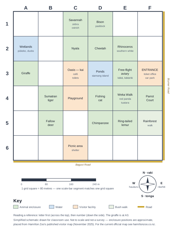
🎯 Navigation Challenges | Ngā Wero Whakatere
Challenge 1: Basic Grid Reading
You're at Point A in the car park (3, 2). Look at the map and answer these questions:
- What grid coordinates would you write for the main entrance building ? ,
- The giraffe exhibit appears to be at approximately: ,
- Can you spot the wetlands area (blue water)? Write its coordinates: ,
Challenge 2: Planning Your Route
From Point A (3, 2), you want to visit three animals:
Route Planning Table
| From | To | Grid Distance (squares) | Real Distance (metres) | Walking Time (at 3 km/h) |
|---|---|---|---|---|
| Car Park A (3, 2) | Entrance ( , ) | _____ squares | _____ metres | _____ minutes |
| Entrance | Giraffes ( , ) | _____ squares | _____ metres | _____ minutes |
| Giraffes | Wetlands ( , ) | _____ squares | _____ metres | _____ minutes |
- Count the grid squares to calculate each distance. Remember: 1 square = 10 metres
- What's your total walking distance for this route? _________ metres
- How long would this walk take at 3 km/h (50 metres per minute)? _________ minutes
Challenge 3: Finding the Shortest Path
Time for some strategic thinking!
- You're at the wetlands and need to get to the tigers quickly. Can you identify where the tigers are and write their coordinates? ,
- Count the grid squares for the shortest route: _________ squares = _________ metres
- If you walk diagonally across grid squares instead of following the paths, how would this change your distance? Explain your thinking:
Challenge 4: Emergency Rescue Mission!
A child has gone missing near the elephants! Zoo staff need to coordinate the search.
- Locate the elephant enclosure on the map. Coordinates: ,
-
If search teams are positioned at these coordinates, calculate how far each team is from the elephants:
- Team 1 at (2, 6): _________ metres
- Team 2 at (8, 4): _________ metres
- Team 3 at (6, 7): _________ metres
- Which team should respond first? Explain why:
Challenge 5: Zoo Expansion Planning
The zoo wants to add a new cafe! Help them choose the best location.
-
The cafe should be:
- Within 50 metres of the main entrance
- Not more than 80 metres from the car park
- Easy for families to reach
- Suggest coordinates for the new cafe: ,
-
Calculate distances to prove your choice:
- Distance from entrance: _________ metres
- Distance from car park: _________ metres
- Justify your choice:
🌟 Extension Challenge: Advanced Navigation
For students ready for more:
- Area Calculation: The main zoo area enclosed by paths covers approximately how many grid squares? _________ squares = _________ square metres
- Perimeter Walk: If you walked around the entire zoo boundary, approximately how many metres would you walk? _________
- Scale Understanding: If this map was drawn to a scale of 1:1000 instead of 1:1000 (where 1cm = 10m), how would the grid system change?
🤔 Reflection | Whakaaro
- Grid Systems: How do grid references help us communicate exact locations? Give an example from your everyday life where this might be useful.
- Scale & Distance: What was challenging about converting grid squares to real distances? How did you check your calculations?
- Problem Solving: Which challenge required the most thinking? What strategies did you use?
🎯 Teacher Notes | Ngā Kōrero Kaiako
Learning Objectives Covered:
- Coordinate Systems: Students plot and read coordinates on a grid
- Scale & Measurement: Converting grid units to real-world measurements
- Distance Calculation: Counting grid squares and applying scale
- Problem Solving: Route planning and optimisation
- Real-world Application: Navigation and spatial reasoning
Differentiation Strategies:
- Support: Work in pairs, use physical rulers on printed maps
- Extension: Calculate diagonal distances using Pythagorean theorem
- Assessment: Students explain their reasoning for location choices
Te Reo Māori Vocabulary:
- Kaiwhakarea: Navigator
- Tauwāhi: Coordinates
- Inenga: Scale, measurement
- Roa: Distance, length
- Mission, task
Kaiako Planning Snapshot
Ngā Whāinga Akoranga — Learning Intentions
- Identify and communicate locations on a zoo map using ordered pairs, grid references, and directional language.
- Use scale to convert grid distances into realistic walking distances and travel times.
- Apply grid-based reasoning to plan routes, compare options, and solve simple spatial problems in context.
Paearu Angitu — Success Criteria
- I can locate exhibits accurately using the grid and explain where they are in words and coordinates.
- I can calculate real-world distances from grid measurements and show how I worked them out.
- I can justify which route or location is better for a given zoo task using evidence from the map.
Teacher Planning Snapshot
- Year level: Years 7-8 | Duration: 1-2 lessons or a short applied-maths sequence using a local map context.
- Curriculum alignment: NZC Mathematics and Statistics Level 3-4 geometry and measurement, with mapping, scale, position, and coordinate reasoning applied in a real-world setting.
- Mātauranga Māori: Grid navigation can be linked to whakatere waka, the careful reading of landmarks, and the way whakapapa and whenua locate people within place. Use kaitiakitanga to frame the zoo not just as a map problem but as a living environment where movement, planning, and care for animals and visitors matter together.
- Entry support: Begin with one shared route from the car park to a familiar exhibit, modelling how to read coordinates, count squares, and convert to metres before students attempt independent navigation tasks.
- On-level: Most learners can read the grid, calculate simple route distances, and explain why one path is shorter or more practical once the scale is clear.
- Extension: Ask students to design a new facility location or emergency plan and justify it using coordinates, distance, and visitor access needs.
Inclusion and Accessibility
- ESOL / ELL: Pre-teach directional and mapping vocabulary with arrows, icons, and sentence frames such as "The exhibit is at..." and "The shortest route is..."
- Accessibility: Offer enlarged maps, high-contrast grids, and the option to trace routes physically with rulers or string before recording answers.
- Neurodiverse learners: Break the activity into one challenge at a time and use checkboxes or worked examples so students can complete each navigation step without losing track of the whole task.
🔗 Unit Progression & Next Steps
🔗 Unit Progression & Next Steps
To be populated in Phase 3: A narrative of this unit's lesson arc. How do students progress from opening inquiry to final synthesis?
Pedagogical Foundations | Ngā Tūāpou Akoranga
Navigating a zoo grid requires spatial reasoning, directional logic, and systematic thinking. Three researchers explain why grid navigation is genuine mathematical learning, not basic mapwork.
→ Explore all theorists at Te Whare Ako — Teaching Theory