🦒 Hamilton Zoo Map Adventure 🐘 Pakihi Kōpere Kirikiriroa
🎯 Your Mission | Tō Kaupapa
Welcome to Hamilton Zoo, explorer! 🎉
You just arrived at the START point in the car park. Now you need to find different animals using our special map!
🗺️ How to Use This Map
- Grid Squares: The map is divided into squares like a chess board
- Finding Places: Use the numbers along the edges to find locations
- Moving Around: Count squares to see how far things are apart
- Starting Point: Look for the red pulsing dot - that's where you begin!
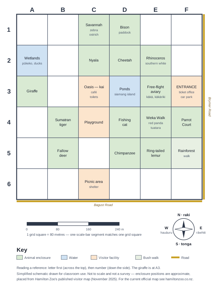
🔍 Activity 1: Finding Animals
Look at the map and find these animals! Write the letter and number for each one.
🦒 Giraffes: Letter Number
🐘 Elephants: Letter Number
🐅 Tigers: Letter Number
👣 Activity 2: Counting Steps
🧮 Counting Helper
How to count squares:
- Put your finger on the START point
- Count how many squares you move across (left or right)
- Count how many squares you move up or down
- Add them together!
From your START point, count how many squares to reach each animal:
| Animal | Squares Across | Squares Up/Down | Total Squares |
|---|---|---|---|
| 🦒 Giraffes | |||
| 🐘 Elephants | |||
| 🐅 Tigers |
🎯 Activity 3: Which Animal First?
You want to visit all three animals, but which one should you visit first?
Look at your counting from Activity 2. Which animal needs the smallest number of squares to reach?
I should visit the first because it only takes squares to get there!
🔍 Activity 4: Treasure Hunt!
There are other cool things at the zoo too! Can you find them?
🎠 Playground: Letter Number
🍕 Food Area: Letter Number
💧 Water/Lake: Letter Number
🤔 Activity 5: Planning Your Day
You're getting hungry! Plan the best route to get food.
You're still at the START point. You want to see one animal, then get food.
My plan:
1. First, I'll visit the
2. Then I'll go to the food area
3. This is a good plan because:
🌟 Activity 6: Help a Friend!
Your friend is lost! They tell you they can see elephants and a playground.
Look at your map. Where do you think your friend is?
My friend is probably at: Letter Number
How do you know?
🎉 Well Done! | Ka Pai!
You've completed the Hamilton Zoo Map Adventure!
You now know how to:
- ✅ Find locations using letters and numbers
- ✅ Count squares to measure distances
- ✅ Plan efficient routes
- ✅ Help others using map references
Ngā Whāinga Akoranga — Learning Intentions
- Students can use alphanumeric grid references (A1, B2) to identify locations on a zoo map.
- Students can count grid squares to estimate the distance between two locations.
- Students can plan a simple route between two points on the grid and describe it clearly.
- Students can compare routes and explain why different paths may be equally valid.
Paearu Angitu — Success Criteria
- I can give the grid reference for at least 3 animal enclosures on the zoo map.
- I can count the squares between two locations and state how many squares apart they are.
- I can describe a route using directional language (rāwhiti/east, hauāuru/west).
- I can explain my route clearly enough for a classmate to follow it.
Teacher Planning Snapshot
Curriculum Alignment
Te Mātaiaho Mathematics and Statistics — Phase 2 (Year 6). Geometry strand: alphanumeric grid references (A1, B2), plotting and reading positions on a grid map. This Phase 2 sub-unit extends the Year 6 grid adventure into a structured modular progression, bridging to coordinate plane work in Phase 3.
Mātauranga Māori Lens
In Waikato tradition, Kirikiriroa (Hamilton) is a place whose every feature carries a name and a story. The zoo sits on land that Waikato iwi have navigated and cared for as kaitiaki. Using te reo Māori compass directions — rāwhiti (east), hauāuru (west), tonga (south), raro (north) — connects the grid system to Indigenous spatial knowledge. The conservation stories of the zoo's endangered species ground the navigation tasks in kaitiakitanga: students navigate toward creatures that need protecting, not just abstract grid squares.
Entry / On-level / Extension
- Entry: Simplified 3×3 grid with large labels and teacher-guided prompts. Physical counters on a printed map.
- On-level: Full 5×4 grid, independent route planning, partner route description.
- Extension: Design own zoo map with grid and write treasure hunt clues. Compare alphanumeric system to (x, y) coordinates.
Inclusion and Accessibility
- Visual: Animal emoji icons and colour-coded enclosures allow visual identification before grid reference use.
- Neurodiversity: One task at a time. Large-format printed version available. Physical tokens for tracking movement.
- EAL/D: Bilingual direction labels (English / te reo Māori). Route descriptions accepted verbally, as drawings, or in any language.
🎯 Teacher Notes | Ngā Kōrero Kaiako
Year 6 Learning Objectives:
- Simple Grid References: Using letters and numbers to locate positions
- Basic Counting: Counting grid squares for distance
- Spatial Awareness: Understanding relative positions
- Problem Solving: Planning simple routes
- Communication: Describing locations clearly
Simplifications for Year 6:
- Bigger Grid: Only 5×4 squares instead of complex coordinates
- Letters + Numbers: A1, B2 format instead of (x,y) coordinates
- Visual Cues: Animal emojis, bright colours, clear labels
- Simple Counting: Just add squares across + squares up
- Real Context: Focus on practical zoo navigation
Extension Ideas:
- Draw their own zoo map with a grid system
- Create treasure hunt clues using grid references
- Use classroom or playground as practice grid
- Compare this map to other maps they know (school, neighbourhood)