🎯 Mission Brief
You're about to become a zoo map expert! 🎉
Look for the red START HERE point on the map.
🧭 What You'll Learn:
- Grid References: Letters and numbers
- Directions: N, S, E, W
- Distance: Counting squares
- Map Skills: Reading symbols
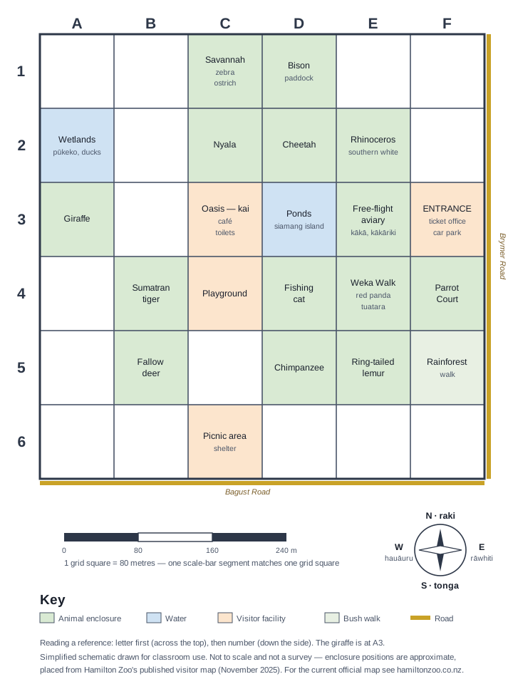
Activity 1: Find the Animals
Your first mission: Find where each animal lives!
Look at the map carefully. Each animal has its own special area.
Giraffes live at: Letter Number
Elephants live at: Letter Number
Tigers live at: Letter Number
Activity 2: Learning Directions
🧭 Direction Helper
From your START point, which direction do you need to go to reach:
The Giraffes:
The Elephants:
Activity 3: Measuring Distances
Let's count squares to see how far you need to walk!
Put your finger on the START point and count squares to each animal.
| Animal | Squares Right/Left | Squares Up/Down | Total Steps |
|---|---|---|---|
| Giraffes | |||
| Elephants | |||
| Tigers |
Activity 4: Plan Your Perfect Zoo Day
You want to visit all the animals, but in what order?
Look at your "Total Steps" from Activity 3. Which animal takes the fewest steps to reach?
My Zoo Visit Plan:
🥇 First, I'll visit: (because it's closest)
🥈 Second, I'll visit:
🥉 Third, I'll visit:
Activity 5: Emergency Helper!
Uh oh! Someone dropped their lunch near the elephants!
A zoo keeper needs your help to find it quickly.
You need to give the zoo keeper directions from the START point to the elephants.
📻 Radio Message to Zoo Keeper:
"From the car park, walk for squares, then walk for squares. You'll find the elephants at grid !"
Activity 6: Become a Zoo Guide!
Congratulations! You're now ready to help other families!
A family asks you: "We want to see giraffes, then get some food, then see elephants. Can you help us?"
🗺️ My Expert Guide Instructions:
1. Giraffes are at:
2. Food area is at:
3. Elephants are at:
My helpful tip:
🎉 Amazing Work! You're a Zoo Explorer! | He Mahi Miharo!
You've mastered today's map skill: grid references!
✅ What You Can Do Now:
- 📍 Find places using grid references
- 👥 Help others using maps
🌟 Coming Up Next:
- 🧭 Compass directions
- 📏 Measuring distance
- 🗺️ Planning routes
🎯 Teacher Notes | Ngā Kōrero Kaiako
📚 NZ Curriculum Phase 2 Alignment:
📐 Geometry & Measurement:
- Use simple grids and directions to communicate position
- Give and follow directions for movement
- Describe position using everyday language and grid references
- Compare lengths and distances informally
🔢 Number & Algebra:
- Count collections and sequences
- Add and subtract numbers using various strategies
- Use number to solve everyday problems
- Communicate mathematical ideas clearly
🎓 Differentiation Strategies:
🟢 Support (Year 4):
- Work with buddy/adult
- Use physical manipulatives
- Focus on Activities 1-3
- Simplified language
🟡 Core (Year 5):
- Complete all activities
- Explain reasoning
- Work independently
- Help support group
🔴 Extension (Year 6):
- Add diagonal movements
- Create own grid references
- Calculate actual distances
- Design new zoo sections
🌿 Cultural Integration:
- Te Reo Māori: Direction terms (raki=north, tonga=south, etc.)
- Wayfinding: Traditional Māori navigation methods
- Place-based: Connection to Hamilton/Kirikiriroa as place
- Conservation: Kaitiakitanga values in zoo context
🎬 Media Anchor (8 mins)
Media Anchor: Grid Explorer Warm-Up
- What grid-reading move should students practise before Activity 1?
- Which common misconception does this clip help prevent?
📋 Teacher Planning Snapshot
Ngā Whāinga Ako — Learning Intentions
- Read and plot alphanumeric grid references accurately.
- Explain spatial reasoning using clear mathematical language.
Ngā Paearu Angitū — Success Criteria
- I can locate and label places using a letter-number grid reference.
- I can explain a route so another person can follow it.
- I can check my answer against the map and correct an error.
Preparation, differentiation and inclusion
- Timing: 60–75 minutes. Print or project the self-contained zoo map; provide pencils, rulers, and optional counters.
- Entry: rehearse “letter first, number second” on a floor grid and use a compass rose card.
- On-level: pairs complete the map challenge, swap directions, and test whether the partner reaches the intended enclosure.
- Extension: compare two routes, justify the shorter route, then use a stated metres-per-square scale.
- Inclusion: offer large-print maps, high-contrast overlays, oral directions, physical floor-grid movement, and one-step direction cards.
- Mātauranga Māori: locate the learning honestly in Kirikiriroa. Use the compass terms raki, tonga, rāwhiti, and hauāuru accurately; seek local guidance before adding mana whenua narratives or traditional wayfinding knowledge.
Curriculum alignment
See the unit curriculum companion for the exact Level 2–3 objectives and lesson evidence map.