📍 Mission Briefing
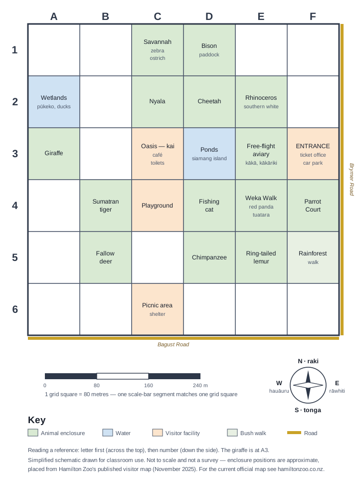
Welcome to Hamilton Zoo, rookie navigator! You've just arrived at the entrance and car park (Point A) and need to navigate around the zoo using the map's grid reference system. Each grid square represents 80 metres in real life.
🗺️ How to Read the Grid Map
- Grid References: Columns are lettered A to F from west (left) to east (right); rows are numbered 1 to 6 from north (top) to south (bottom). Write the column letter first, then the row number — e.g. the entrance is in square F3
- Scale: Each grid square = 80 metres × 80 metres
- Starting Point: The entrance and car park are in square F3 — this is your Point A
- Measurements: Count grid squares along the rows and columns (across, then up or down — no diagonals) to find distances between locations
🎯 Navigation Challenges | Ngā Wero Whakatere
Challenge 1: Basic Grid Reading
You're at Point A — the entrance and car park (F3). Look at the map and answer these questions:
- What grid reference would you write for the Oasis café and toilets?
- The giraffe enclosure is in square:
- Can you spot the wetlands (blue water)? Write its grid reference:
Challenge 2: Planning Your Route
From Point A (F3), you want to visit the café, the giraffes, and the wetlands:
Route Planning Table
| From | To | Grid Distance (squares) | Real Distance (metres) | Walking Time (at 80 m/min) |
|---|---|---|---|---|
| Entrance & car park (F3) | Oasis café (____) | _____ squares | _____ metres | _____ minutes |
| Oasis café | Giraffes (____) | _____ squares | _____ metres | _____ minutes |
| Giraffes | Wetlands (____) | _____ squares | _____ metres | _____ minutes |
- Count the grid squares to calculate each distance. Remember: 1 square = 80 metres
- What's your total walking distance for this route? _________ metres
- How long would this walk take at 80 metres per minute (≈4.8 km/h)? _________ minutes
Challenge 3: Finding the Shortest Path
Time for some strategic thinking!
- You're at the wetlands (A2) and need to get to the Sumatran tiger quickly. Find the tiger on the map and write its grid reference:
- Count the grid squares for the shortest route (across, then down): _________ squares = _________ metres
- If you walk diagonally across grid squares instead of following the rows and columns, how would this change your distance? Explain your thinking:
Challenge 4: Emergency Rescue Mission!
A child has gone missing near the chimpanzees! Zoo staff need to coordinate the search.
- Locate the chimpanzee enclosure on the map. Grid reference:
- If search teams are positioned at these locations, count the grid squares (across, then up or down) to calculate how far each team is from the chimpanzees:
- Team 1 at the fallow deer (B5): _________ metres
- Team 2 at the cheetah (D2): _________ metres
- Team 3 at Parrot Court (F4): _________ metres
- Which team should respond first? Explain why:
Challenge 5: Zoo Expansion Planning
The zoo wants to add a new cafe! Help them choose the best location.
- The cafe should be:
- No more than 2 grid squares (160 metres) from the entrance and car park (F3)
- In a square that is not already an animal enclosure
- Easy for families to reach
- Suggest a grid reference for the new cafe:
- Calculate distances to prove your choice:
- Distance from the entrance and car park (F3): _________ squares = _________ metres
- Distance from the playground (C4): _________ squares = _________ metres
- Justify your choice:
🌟 Extension Challenge: Advanced Navigation
For students ready for more:
- Area Calculation: Count the shaded squares (enclosures, water, and visitor areas). How many grid squares do they cover, and what is that area in square metres? (Remember: one square = 80 m × 80 m = 6,400 m².) _________ squares = _________ square metres
- Perimeter Walk: The mapped area is a 6 × 6 grid of squares. If you walked right around its boundary, how many metres would you walk? _________
- Scale Understanding: On this map one grid square = 80 metres. If a new map of the same zoo used one grid square = 40 metres, what would happen to the number of squares needed — and what could you show in more detail?
🤔 Reflection | Whakaaro
- Grid Systems: How do grid references help us communicate exact locations? Give an example from your everyday life where this might be useful.
- Scale & Distance: What was challenging about converting grid squares to real distances? How did you check your calculations?
- Problem Solving: Which challenge required the most thinking? What strategies did you use?
🎯 Teacher Notes | Ngā Kōrero Kaiako
Learning Objectives Covered:
- Coordinate Systems: Students plot and read coordinates on a grid
- Scale & Measurement: Converting grid units to real-world measurements
- Distance Calculation: Counting grid squares and applying scale
- Problem Solving: Route planning and optimisation
- Real-world Application: Navigation and spatial reasoning
Differentiation Strategies:
- Support: Work in pairs, use physical rulers on printed maps
- Extension: Calculate diagonal distances using Pythagorean theorem
- Assessment: Students explain their reasoning for location choices
Te Reo Māori Vocabulary:
- Kaiwhakarea: Navigator
- Tauwāhi: Coordinates
- Inenga: Scale, measurement
- Roa: Distance, length
Curriculum alignment
- Geometry — Knowledge: - Spatial language can be used for giving and following instructions (e.g. near, far, next to, beside, on top, under, over, down, up, left, right, turn).
- Measurement — Practices: - Using Pythagoras’ theorem to:find the length of an unknown side in a right-angled trianglecheck if a triangle has a right anglecalculate the distance between two points in t…
📋 Teacher Planning Snapshot
Ngā Whāinga Ako — Learning Intentions
Students will apply mathematical thinking to authentic contexts at Te Kāhui Kararehe o Kirikiriroa (Hamilton Zoo), developing tūhuratanga (statistical inquiry) skills through real data about animal populations, habitats, and conservation. This unit connects maths to kaitiakitanga — our responsibility to care for ngā manu me ngā kararehe of Aotearoa.
Ngā Paearu Angitū — Success Criteria
- ✅ I can collect, display, and interpret data about animals using appropriate graphs and statistics.
- ✅ I can apply measurement, geometry, or number skills to solve real problems in a zoo context.
- ✅ I can connect mathematical findings to conservation and kaitiakitanga for native species.
Differentiation & Inclusion
Scaffold support: Provide pre-drawn graph templates and data tables for entry-level access. Offer extension tasks requiring students to design their own statistical investigation using zoo population data and write a conservation recommendation backed by evidence.
ELL / ESOL: Pre-teach mathematics and conservation vocabulary. Use visual supports — diagrams, models, and real objects where possible. Allow students to explain their mathematical thinking verbally before writing.
Inclusion: Offer manipulatives and calculator access to support all learners. Neurodiverse learners benefit from structured inquiry frameworks, clear success criteria, and choice in how they present mathematical findings. The hands-on, real-world context of zoo mathematics motivates engagement across learning profiles.
Mātauranga Māori lens: Connect to traditional Māori knowledge of kararehe and manu — including the significance of native species like tuatara, kiwi, and kākāpō in tikanga Māori. Use maramataka (traditional Māori lunar calendar) as a context for data and pattern recognition. Frame conservation mathematics as a practical expression of kaitiakitanga.
Prior knowledge: Best used after foundational statistics and measurement skills. Connects well to science ecology units.